OneBusAway (beta) is Made Available to MARTA Riders

5 Mar

Happy Tuesday!

OneBusAway helps MARTA riders know when the next bus is coming.

A couple of months ago, MARTA released their real-time tracking info for buses.  Now some cool apps are starting to hit the market.  This is one that I think is particularly useful.  It’s called OneBusAway and it has been opened for beta testing by students/researchers at Georgia Tech.  It consists of a website, iPhone app, and Android app.  The apps take a little editing of settings to get to work right for Atlanta, but it’s a pretty cool app once it is setup.  It is based off of the OneBusAway instance originally deployed in Seattle, WA.  

For more information about how to access the website and apps, go to http://onebusaway.gatech.edu.

Why is it so hard to walk to a MARTA station?

4 Mar

Merry Monday!

What is the purpose of MARTA stations?  I clearly have the wrong idea about how the MARTA system was supposed to work.  I was thinking that these stations were intended to make it easy to get around Atlanta without a car.   Obviously, I am way off the mark with that thought.  Because, in order for stations to be convenient for pedestrians, they need to be located in walkable areas and they need to be designed in such a way that they are easy to approach on foot.

If you have used rail systems in other American cities (for instance, Boston, Washington D.C., New York, Chicago, Seattle, San Francisco, Portland, New Orleans, Salt Lake City, Philadelphia, etc.), it is apparent that a lot of thought went into how pedestrians will interact with the stations and how pedestrians will access the surrounding areas.  Because of this, those cities have transit stations with small footprints, located in areas of the city where walking is not an extreme sport.  Below are some images of properly designed transit station entrances.  Notice that they are all small and very unobtrusive.

Locust Street in Philadelphia, PA

6th Avenue and 14th Street Subway Entrance in NYC.

Dupont Circle METRO entrance in Washington D.C.

What do we get in Atlanta?  For some reason the station designers back in the early days of MARTA thought that we needed giant bunkers and block-sized compounds for transit stations.  Take a look at Arts Center Station below.  This station is located in one of the most walkable areas of Atlanta, yet it was decided that an entire block of prime real estate is required to get passengers onto an underground train.

Arts Center MARTA Station, Midtown, Atlanta

Unfortunately, this is actually one of the more pedestrian friendly MARTA stations in Atlanta.  I’ve spent a lot of time riding MARTA and have visited nearly every station personally.  What I’ve noticed is that only a handful of stations are even designed for pedestrian access. The vast majority of stations are meant to accommodate cars.  I know that seems weird, but it’s true.  The MARTA rail stations are much more accepting of individuals arriving by car than by foot.  I suppose the idea was for these stations to act as suburban hubs where people would transition between their autos and transit.  But most of these stations aren’t in the suburbs.  Some are less than a mile from the state capitol.  Check out these stations below.  Notice how they are surrounded by trees and parking lots.  They are not easily accessed on foot.

Plenty of Parking at East Lake MARTA

Plenty of Parking at Edgewood

Medical Center Station

King Memorial Station. Great access for the dead, not so much for pedestrians.

Oakland City Station.

Sandy Springs Station. At least this one has a taxi stand, because walking around here sucks.

It’s not all bad though. Some MARTA stations are OK. Some are located in pedestrian areas, and a couple even resemble the simple easy access stations like those from DC, Philly, and NY. Check out some of the better MARTA station examples below.


Hey check it out!   A MARTA station in a walkable area that is small and unobtrusive (Peachtree Center Station).  That’s what I’m talking about! To make this image even more attractive, pretend that there are crosswalks here. 


Check out the MARTA station in Decatur above.  It’s pretty hard to see because it doesn’t occupy an entire block.  It fits right in with its surroundings. Decatur is a great walkable area with easy access to rail transit.


Above is Midtown station.  It’s not the best design.  It’s too big and surrounded by roads that are very inhospitable to pedestrians.  But it is near actual stuff so that makes it one of the better MARTA stations.  We have pretty low standards here.

So Atlanta doesn’t have many stations that are truly small, unobtrusive, and in walkable areas.  Of the 38 total MARTA stations, there are only 8 that I would considered to be a ‘Good’ design.  That leaves 30 stations with Bad design or merely OK design.  I took a quick survey of all the MARTA stations and tried to determine which ones are Good, OK, or Bad.   I’ve posted that very quick survey below along with a Google Maps link to each station as well as the walk score for each station as a quick reference for each station’s walkability.  Please keep in mind that this “study” is very subjective and represents my own very uneducated opinion.

Good MARTA Stations

(These stations are designed reasonably well and are located in walkable areas.)

Decatur 86

Georgia State 95

Buckhead 80

Peachtree Center 97

Civic Center 94

North Ave 91

Midtown 83

Five Points 95 

OK Marta Stations

(These stations contain SOME of the characteristics of a well designed station.) 

Arts Center 88, (What is up with the crazy unwalkable design.  It could have been so much better.)

GWCC 85

Ashby 58, (Low density area.  Can’t blame that on MARTA.   But building a giant parking lot on the site doesn’t help things either.)

Vine City 65,  (The area is very low density, can’t blame that on MARTA.  The Georgia Dome and GWCC screw up this neighborhood.)

Airport 58

Garnett 82

Lindbergh 66, (The Transit Oriented Development around here is nice, but it feels like window dressing to me.  Once you walk out towards Piedmont Ave., you realize that you are a pedestrian stranded in a car desert)

Lenox 65

Bad MARTA Stations

(These stations give little or no thought to pedestrian access.) 

Edgewood/Candler 68

East Lake 54

Inman Park 83

Avondale 69

Kensington 42

Indian Creek 25

King Memorial 78

West Lake 35

Holmes 49

Bankhead 25

West End 85, (Why the fencing and the difficult entry?)

Oakland City 38

Lakewood 40

East Point 67

College Park 65

Medical Center 52

Dunwoody 68

Sandy Springs 72

North Springs 29

Brookhaven 78

Chamblee   75

Doraville 75

I didn’t write this just to bash MARTA, even though that is Atlanta’s favorite pastime.  These stations were designed years ago, in a very different era.  The current regime at MARTA had nothing to do with making these decisions, and I don’t really know what MARTA can do about it at this point.  I write this to point out a couple of things.

1) MARTA never really had a chance at being an effective conveyance for car-free individuals within the city.  The stations are too far apart.  The stations are too big, and only a very small handful of stations are actually designed reasonably well AND are located in walkable areas.  The vast majority of stations are built for car drivers.  It was like MARTA was intended to be a crutch for motorists who didn’t want to deal with downtown parking.  Well that problem was eventually solved by simply bulldozing most of downtown to build more parking lots.

2) The City of Atlanta needs a true intra-city, light rail, transit system.  The handful of urban MARTA stations do not get the  job done.  They were designed for regional travel, not local travel.  Having MARTA heavy rail without light rail is like having an interstate without having local roads.  There are enough residents in Atlanta to support a system with more stations and more local service.  It is my hope that the downtown streetcar will start to fill that need.

In other random news…

Five Reasons I’m Optimistic about Atlanta

25 Feb

Happy Monday,

Living as an urban enthusiast in Atlanta can be difficult.  Apparently parks, museums, walkability, safe cycling routes, good food, fun pubs, and cultural diversity are things that most people around here seem to not enjoy.  Because of this, it’s easy to get discouraged in this town.  To help myself out of the doldrums, I devised a list of 5 things that make me hopeful for this city.

1) The Downtown Streetcar is Moving Forward

The City of Atlanta is installing it’s first streetcar line 64 years after the last streetcars were removed from Atlanta streets.   The streetcar lines connects Centennial Park, Fairlie-Poplar, Downtown, and the Old Fourth Ward at the MLK Center.

I am hopeful that this project is a success.  A successful streetcar line would lead to further expansion, more connection points to MARTA, connection to the Beltline, and eventually a true streetcar system for the City of Atlanta.  Such a system would provide a level of car-free mobility that Atlanta hasn’t seen in over half of a century.

The task is tall however.  Much of the area where this streetcar is to be installed is blighted, and there is heavy risk in staking this much capital in an “up-and-coming” neighborhood .  If the streetcar proves unsuccessful in improving the economy and livability in the service area, especially the areas within a few blocks of the interstate, then naysayers will cite that failure as hard evidence that Atlanta is not fit for streetcars.  On the other hand, if the streetcar is successful and makes a large positive economic impact on the downtown communities, then it will be impossible to deny that a streetcar network should be expanded throughout the city.

As an aside on this topic, I must admit that I’m worried about headways.  First impressions are important for new systems.  If people are unsatisfied with their first trip, then they may never give the system another chance.   Because of this, I am worried about the reported 15 minute headway projected for this project.  One streetcar every 15 minutes is not very frequent.  With such a short rail line, I would more likely walk than wait 15 minutes for service.  It only takes 2 streetcars to operate at 15 minute headways on this line.  The City of Atlanta owns 4 street cars.  In order to make a solid first impression, these streetcars should operate at no more than 10 minute headways.  If ridership is low, then headways can be increased.  

2)  Marta Releases Real-Time Data

Back in October, MARTA released its real-time bus data and the GTFS schedule data for its buses and trains.  Since then, the real-time bus feed has been continually refined and improved by the hard-working people at MARTA in order to give consistent and accurate updates about bus locations.  I know of several 3rd party developer teams who are working to release apps that take advantage of this data.

In the coming weeks, I hope to see good apps hitting the market.  Real-time bus data will have a dramatic effect on the practicality of MARTA.  We all know that many of MARTA’s routes suffer from very long headways.   Some buses operate at 40-60 minute headways, even during peak weekday hours.  In addition to the long headways, the buses are often late or early depending on the notoriously unpredictable Atlanta traffic.

It is very stressful to be waiting at a bus stop, with no shelter, no sidewalk, on the side of a 7 lane highway, in July heat or February freeze and wondering if the bus is ever going to show up.  Is the bus 10 minutes late or did it come early?  Well, real-time data can’t fix all these problems, but at least you would  know where the bus is and when it is coming.  Then you don’t have to wait at one of our city’s lovely dignity-free MARTA stops while being stared at by every driver passing you by.  You can walk out to the stop moments before your bus arrives and forget all the extra stress and associated nonsense.  If the bus is going to be 10 minutes late, I would rather spend that time inside the Starbucks.

3)  Cycling Infrastructure is Improving

Atlanta is getting some good momentum on the bicycle infrastructure front.  There seems to be a consensus among advocates and city politicians and planners that Atlanta needs to seriously embrace bicycling as a legitimate mode of transportation.  This is evidenced by current and upcoming bicycle projects that will connect important and practical locations around town.

For instance,

  • Ponce de Leon is getting separated bicycle infrastructure this summer.  This will allow bikers to easily travel from Peachtree St. and the North Ave MARTA Station to the Beltline, Ponce Market, and the Whole Foods shopping center.
  • 10th Street is also getting separated infrastructure to safely move bikers between Midtown and the Beltline.
  • Juniper Street is getting a total overhaul.  The overhaul will lead to fully separated bike paths, intersection improvements, and vastly improved sidewalks.  It will be a great walkable complement to Peachtree Street one block to the west, and it will also serve as a much needed southbound bike route through midtown.  I don’t have a link to the project page, but the image above is from an open house held earlier this month describing the project.
  • In addition to these projects, a host of other projects that extend far beyond midtown, and totaling $2.5 Million, are described on the Atlanta Bicycle Coalition website.

4)  Start-Up Culture in Atlanta is Gaining Ground

The Atlantic: A Visual Guide to Atlanta’s Startup Scene

OK, this is the one entry of the five that is not transportation related.  Efficient transportation and a vibrant urban setting are impossible and useless without a strong economy and jobs for Atlantans.  I would love to see a strong start-up culture here.  Atlanta has a lot going for it in this area.  We have great universities (e.g., Georgia Tech, Georgia State, Emory, the schools at the Atlanta University Center).  Atlanta is affordable.  It is much more affordable to live an urban lifestyle in Atlanta versus other similar cities.  We have a ridiculous airport that makes Atlanta a great place to base a national or international company; it’s easy to get anywhere from here. And, we are also home to more than our fair share of Fortune 500 companies.

Atlanta seems to have the necessary pieces for a strong start-up scene and that is being recognized around the region and country.  More start-ups were funded in Atlanta last year than any other southern city. (We don’t count Texas because they aren’t real southerners.)   With the ongoing success of ATDC, FlashPoint, Atlanta Tech Village, Hypepotamus, and countless other start-up accelerators and services, I expect Atlanta’s tech start-up scene to start making more and more noise nationally and internationally.

5)  BeltLine Popularity is Out of Control

Nobody goes to the BeltLine anymore.  It’s too crowded.  

beltline

The popularity of the East Side Trail shows just how much latent demand there is for walkable places in this city.  So much so that some people are beginning to fight over the limited pavement space on the EST, for instance, the guy discussed in this article in Curbed.  Overcrowding is a problem.  But it’s a good problem to have and much better than the alternative.  It’s oddly refreshing to hear people griping about Atlanta traffic that does not involve cars.  It’s actually kind of mind-blowing.

This popularity of this section of the BeltLine has led to the stores and restaurants adjacent to the BeltLine to transform what used to be their rear entrances, parking lots, and dumpster sites into welcoming patios and front entrances to accommodate this new source of customers.  What used to be vacant industrial sites around the East Side Trail are now prime real estate for Atlanta’s latest awesome amenity.

The popularity of the BeltLine and the reaction of the adjacent businesses gives me hope that more similar developments will also be well received.  The East Side Trail is just a small start for building a thorough network of practical cycling and walking paths in Atlanta.  I hope that this section of the BeltLine will eventually have transit connecting it to the downtown streetcar and potential midtown streetcars in the future.  Can you imagine having a streetcar circuit that connected the East Side Trail, the downtown streetcar, 10th street, 14th street and the West Midtown area on Howell Mill?  That relatively small circle would be a fantastic streetcar network for midtown and downtown Atlanta.  I might be dreaming a bit, but it’s fun to  imaging having that type of car-free connectivity in Atlanta.

In other news…

  • Rebecca Serna of the Atlanta Bicycle Coalitions responds to Melissa Carter‘s ill-informed anti-cyclist diatribe.
  • Apparently car rental taxes are being considered to fund transit in Atlanta.  I’m not sure where I stand on this issue, but I do know that it’s absurd that the current rental car tax is used to pay for the Philips Arena.  What in the hell does me renting a car to drive out of town have to do with the Atlanta Hawks?
  • Some new high rises are suggested for Midtown.  Whoopeedeedoo!

I don’t like driving. Does this make me a bad American?

18 Feb

I like to live in walkable areas.  I like bicycling to get groceries.  I like living near parks.  I like sidewalks and bike lanes.  I don’t like driving out of necessity.

Because I like these things, I have been called a hippie liberal.  I have even been called anti-American.  It’s probably because I live in Georgia.  I have been told that walking, biking, and transit are bad for  the economy and that paving over cities to make room for cars and parking is good for the economy.  We will all be better off if cars are given more and more of our valuable urban real estate.

I’m not an economist.  I don’t like walking and bicycling because they are good for the economy or even because they are “green”.  I just like them because I enjoy them.  However, many people, notably Randall O’Toole of the Cato Institute equate driving with prosperity.  He argues that driving is good for the economy and driving more will improve the economy.  Mobility is the key here, and accessibility is less relevant.   Take a look at the graph below for evidence.  The data here is from Randall O’Toole’s 2009 book Gridlock.  It shows per capita GDP and average miles traveled by Americans between 1800 and  2000.  From this data, he basically concludes that smart growth is bad and that we should live in a car-dominated society or else face economic catastrophe.  This is because driving cars more miles leads to a more productive populace.

It’s hard to disagree with graphs like this.  Except for the minor detail that correlation does not equal causation, it seems evident that my hippie, urban-elite, liberalism is going to destroy America.  So I have actually been down on myself a lot for the past couple of years since reading his book.  I don’t want to be a bad person.  I just want to ride my bicycle and walk instead of driving, and I want others to be able to do it too.  (Notice the wording here anti-urbanists conspiracy theorists.  I said “be able to” not “force to”.  I’m not a dictator)

Because I feel guilty for destroying our American way of life, I am always looking for evidence that indicates that maybe I’m not such a bad person after all.  I know.  It’s like an alcoholic looking to justify his behavior.  Anyway, today was a good day for me because I read an article in the Atlantic Cities.  The article, called Cars and Robust Cities are Fundamentally Incompatiblemade me feel like a less terrible person for advocating against handing over our cities to the automobile.  

The article reports a study of cities in New England that have either limited parking or increased  parking since 1960.  The results are very weird because they seem to indicate that limiting parking and building more accessible places may not be the job killer O’Toole had me believing.  Jobs and income have actually grown in the cities that limit parking faster than the other cities.  Now I know that this is just a small study with a small sample size, but it does possibly indicate that maybe there is more to GDP and productivity than merely how many miles we each drive.

The arguments that I hear most often against transit, bicycle infrastructure, and even building walkable areas is that those projects will impede automobile travel.  It is widely believed that impeding automobile travel will have strong negative effects on the economy.  Like a said, I’m not an economist.  I just like living in pleasant areas away from hordes of exhaust-belching, noisy, and aggressive automobiles.  If living in pleasant areas destroys America, then I have serious problem.  But somehow I think that building smart cities doesn’t destroy economies.  I’m actually inclined to believe the opposite is true.  If anyone out there, who is smarter than me, knows of more studies that compare rail, bicycle, parking, pedestrian, or automobile infrastructure and economic indicators, I would like to read them.  I won’t be able to continue working to build nice places until I know that I am not simultaneously destroying our society.

Education, debates, demos, and discussion at Transportation Camp South

12 Feb

This past Saturday, TransportationCamp South took place at Georgia Tech.  Innovators from around the City, State, and Region came together for one day of discussions, demos, and education related to transportation in the South.

TransportationCamp South is the latest iteration of a series of TranportationCamp “un-conferences”.  At these un-conferences, people show up with ideas that they want to discuss, demos they want to show off, or debates they want to lead.  They promote these ideas by posting them on large post-it notes, and a very small team of organizers very quickly compiles a schedule of hour-long sessions taking place in a dozen different rooms throughout the day.  If your topic is picked for a particular round of sessions, you lead that session.  If not, you get to attend one of the other awesome sessions selected.  It is essentially a crowd-sourced conference. 

The conference attracts civil and transportation engineers, city planners, computer programmers, advocates, officials, and general enthusiasts of transportation issues.  All these people with varied backgrounds mix and mingle at a wide array of sessions that you won’t find at most conventional conferences.

Photos from TransportationCamp South.  Find these and more on Facebook

This slideshow requires JavaScript.

Session topics cover a wide array categories such as technical demos of real-time transit tracking apps (like OneBusAway, which hopefully will be available in Atlanta very soon), history reviews of freeways and transit in the South, a debate of the role and impact of autonomous cars in urban transportation, and more whimsical topics like “MARTA Pickup Lines”, which sounds silly but is actually a group of transit advocates promoting transit use through humorous and often sardonic social media events called TransitThursdays.  I don’t do Twitter, but I may have to start this week.

Some cool stuff that I got to see and learn:

I now know that the reason that there is so much green space around Freedom Parkway and Inman Park (see the areas inside the orange lines).  It’s because hundreds of homes were bulldozed to make way for an interstate that never came.  Guess who put a stop to that interstate…it was Jimmy Carter.  Guess where the Jimmy Carter Library is, at the intersection of these interstates that never happened.

I got learn more cool history, like the reason that Gwinnett and Clayton have representation on the MARTA board.  It’s because in 1965 they voted YES to the MARTA Act.  The MARTA Act created an agency to plan future transit in Atlanta.  In 1971, Clayton and Gwinnett vote NO to actually funding the transit plan.   So Clayton and Gwinnett are still on the planning board but have no MARTA service because they don’t want to fund it.  Cobb has always been in the NO category.

There was also a demo of some cool apps resulting from MARTA releasing their real-time bus data.  OneBusAway, which was developed at the University of Washington for transit in Seattle, is being tested at Georgia Tech.  I’m hoping that it will be available publicly in Atlanta sometime soon.  It is only a matter of time before a variety of real-time tracking apps are available in Atlanta.  See the image below for a preview (click to enlarge).

I also learned that self-driving cars are going to let us have our cake and eat it too.  Forbe’s says by 2040 self-driving cars will dominate the roads.  This means that anyone who wants to live way out in the country and still work in the city will have a no-hassle commute.  It also means that all the parking and dangerous cars in city-centers will be removed to build Jane Jacobsian paradises.  Finally, transit Utopia.  Or maybe none of that will happen and we’ll live in gridlock hell because toddlers will all of a sudden have cars just like kids have cell phones today.  Who knows?  It was great to hear opinions on how self-drivings cars will impact safety, transit/highway use, land development and vehicle ownership.  Do we really need to own cars once they can drive themselves?  I say NO!  Others say YES!  Maybe we can both win.   Attendees of this meeting decided to continue this discussion with monthly meet-ups.  If you are interested in talking about impacts of self-drivings cars in Atlanta and want to be ahead of the game, drop me a line.  

Bottom line, TransportationCamp South was a fun and educational event.  Far more happened than I care to write about here.  If you want to learn more about it, check out the Facebook page and keep an eye out for TransportationCamp South 2014.  

Three Posts in One: Because January was Busy

28 Jan

I’m trying to post more regularly, but there is so much going on that I can barely find the time.  It is a good kind of busy.

Transportation Camp and T.R.B.

I just wrapped up a trip to Washington D.C. to visit TransportationCamp D.C. and the annual meeting of the Transportation Research Board.

TransportationCamp D.C. was an awesome event.  It was held at George Mason University’s Arlington campus.  TransportationCamp is billed as an un-conference.  Basically what that means is that the event is driven by the participants in an ad-hoc fashion.  With 400 participants, that is no small order.  Surprisingly, everything went really smoothly, even the 400-person introduction to start the day.  Quick give your name, affiliation, and a three-word introduction on anything you want.  I said, “Make Carefree Easy”.  The most entertaining introductions were  “I need work” and “We are hiring!”

TransportationCamp was a great place for networking.  The un-conference environment made peers of everyone.  There was not this default hierarchy that you often find with traditional conferences.  At TransportationCamp, leaders from MTA in New York and Google Transit rubbed shoulders with mere grad students such as myself.

The session topics varied widely, from how to design software for paratransit and integrate transit schedule data from multiple agencies, on the technical end of the spectrum, to convincing non-transit users to support transit and instructions on failing a transportation referendum, on the advocacy side of the spectrum.  Atlantans are experts at failing referendums.

I am excited for TransportationCamp to head south next month.  Saturday, February 9th, TransportationCamp will be at Georgia Tech for the first T.C. in the Southeastern region.  I am really looking forward to seeing what sort of crowd shows up (spots are filling up fast).  We all know that the South is a special place where innovative transportation and transit is somewhat lacking.  The most creative Atlanta tends to get is proposing to double-deck interstate-285 or building a second connector through the Virginia Highland neighborhood.  But that sort of shenanigans is on the way out.

The rest of my week was filled with attending the overwhelmingly huge Transportation Research Board Annual Meeting.  I could spend days discussing this 11,000+ participant event,  but I won’t.  I will boil it down to two interesting thoughts.

1) I attended two committee meetings at TRB.  The committees at TRB are responsible for reviewing and accepting papers as well as guiding future research in their field.  The two meetings I attended were Emerging Technologies in Public Transportation Committee and the Paratransit Committee.  What I found interesting is that in BOTH of these totally separate committee meetings, the topic of self-driving cars came up.  These committees are curious about the effect of self-driving cars on the role of public transportation and paratransit.  As someone who believes that self-driving cars will have a major impact on not only transportation, but also the design of cities and even basic human interaction, it was reassuring to see that people in roles to guide future research were beginning to prepare for the eventual and inevitable arrival of autonomous vehicles.  How will our cities adapt to this new paradigm altering technology?

2)  I was lucky enough to hear a keynote address from the Secretary of Transportation, Ray LaHood.  TRB is a large umbrella organization that covers every conceivable form of transportation, air, water, highway, transit, pedestrian, bicycle, roller blades,  hot air balloons, etc. etc. etc.  In a room of several hundred distinguished guests that represent every conceivable form of transportation, Ray LaHood chose to spend his time discussing transit, cycling, and pedestrian-friendly cities.  It was encouraging.  Not that he didn’t spent some time on highways and improving highway safety, but it was obvious that his main motivation was to improve non-car options in the USA.

Small Thoughts on D.C. versus Atlanta

Getting  to spend a week in Washington D.C., you really notice some glaring differences between Atlanta and more walkable cities.  There are a couple of obvious improvements that Atlanta could make to become much more walkable.

1)  Introduces some medium density town homes.

It seems that Atlanta jumps between super dense swanky high rises to straight up sprawl with very little in between.  What little there is in between, namely the midtown neighborhood between 10th St., North Avenue, Monroe Dr., and Peachtree Street, is crazy expensive compared to the rest of the city.  I can’t afford a million dollar detached home with 1/4 acre yard in midtown Atlanta.  Why can’t we make some more town homes and fill in that gap between run-of-the-mill condos and detached homes?  Something like the street below should be replicated more often in the neighborhoods adjacent to Peachtree Street. I like urban living, but I also like having my feet on the ground.

A small stretch of town homes in midtown Atlanta.

Washington D.C. is covered with medium density homes.  Actually the density is probably too low for that particular city as home prices are through the roof, but I think this type of development would work great in Atlanta.

A typical street in the Dupont Circle neighborhood in Washington D.C.

2) Fix the sprawled out MARTA stations. 

Take a look at Arts Center Station below.  Transit stations are supposed to be hubs of pedestrian activity.  What do you see here?  A giant hulking compound with no street facing stores and pedestrian destinations that are unnaturally separated by the sprawling MARTA station.  When one leaves the MARTA station there are few shops to enter.  Just outside the view of this photo is a pizza shop, hair salon, and apartment complex.  Unfortunately, they are not easily accessible from the rail station because of the 5-lane mini interstate that is W. Peachtree street.  Also, notice the High museum in the background and the large parking deck to the right side of the picture. There is no pedestrian access noticeable.  Despite this being one of a handful of in-town transit stations, everything is car oriented with little thought given to the pedestrian experience.  My camera couldn’t even capture the entirety of this MARTA station.   Only about half is shown.  To the left of this picture is a giant vacant lot devoid of sidewalks or easy cut-thrus for walking.  Most of the time that I walk through here, I am not even using MARTA so this giant concrete bunker becomes nothing more than a large impediment.  The station actually triples the time that it would take me to reach the High museum from where this picture was taken.  C’mon MARTA.  I know that this was designed decades ago and now we are stuck with it, but can we not encourage a little development around or even above the station?

Compare the image above with a typical station in D.C.  The interior of their stations are just as large as MARTA stations, but the entrances are small and out of the way.  Take some time to move around this Street View link.  Notice how much development there is directly adjacent to the transit entrance.  That is how to do it.  Transit stations are sources and sinks for pedestrian traffic.  The surrounding areas should be custom built to encourage pedestrian activity and take advantage of their presence.

Atlanta Bicycle Coalition

I finally renewed my membership!  It really is a great bang for my buck.

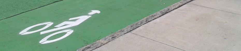
Over the past few years, I have noticed a huge improvement in cycling infrastructure in midtown and downtown Atlanta: new bike lines, sharrows, our first bike signal, etc. etc.  I make a small annual donation for membership to ABC and a team of dedicated advocates fight for my rights.  What a bargain!

I just want to thank all those people who work hard to get these improvements put into place.  I know that metro-Atlanta tends to have a very negative attitude towards any mode of transportation that doesn’t involve at least 4 wheels and 2+ tons of steel.  So it is great to have an organization like the Atlanta Bicycle Coalition going out there and fighting for my rights every day.

2013 already has a big list of projects.  

Atlanta Bicycle Ridership Map!

24 Jan

Back in October, Georgia Tech introduced an app called CycleAtlanta.  The app allows city planners and bicycle advocates know where bicyclists are traveling in order to improve the infrastructure in our city.  Well the early results are in.  Check out the images below to see where cyclists have been traveling in our city.  Keep in mind that this data is pretty raw, but the results are still very interesting.

Click the Pic for a Larger View

City-wide bike patterns. The thicker the line, the more frequent the travel.

There is a pretty strong presence in midtown and downtown Atlanta as well as east towards the Eastside Trail and Freedom Parkway.

Detail of Midtown.

Notice how Spring street has almost no bike traffic and despite the fact that West Peachtree has a dedicated lane, traffic is low there as well.  That’s because the West Peachtree lane is far too narrow to be safe and cars travel very fast on that road. I was surprised to see how many people use Peachtree Street though.  I don’t like Peachtree Street, although I use it very often because it is the safest way to travel North/South across 10th street.

Downtown Atlanta.

There is not as much traffic downtown as I would have thought.  Although, because this is a Georgia Tech app, it should not be surprising that a lot of early adopters ride in midtown.

Eastside.

It is awesome to see how thick and red the Eastside trail is.  That is some solid evidence that building good bike infrastructure will encourage ridership.

This is just the first round of early data coming from CycleAtlanta.   Thanks to Chris Le Dantec and his team at CycleAtlanta for putting this data together.  It is very exciting to see some tangible evidence of Atlanta’s cycling presence.  I look forward to more results and data coming out of the project in the future.

It’s a Wonderful Study of Transportation and Urban Design Through Time

25 Dec

This weekend, I was enjoying an annual viewing of It’s a Wonderful Life.  No Christmas is complete without it.  

What I found interesting was the ‘progression’ of transportation through the years and the way that the small town of Bedford Falls adapted around it.

See below for descriptions and short clips of various snapshots of Bedford Falls through the early 20th century.

1919

In 1919, there was a nice mix of horses, pedestrians, bicycles, and even automobiles.  Walking is the most common mode of transportation, and the cars on the street move slowly to accommodate the other road users.  Notice the car waiting behind the kids walking down the center of the road at 5:08.   The kids weren’t run over or honked at.  The car driver was frustrated, but he didn’t act like he owned the road or anything like that.  What’s also cool is that kids can walk unattended to the soda shop.  No minivan or SUV escort is required.  

(Feel free to stop watching after 15-20 seconds.  All these clips will play the entire movie.)  

1928

In 1928, Bedford Falls is still a really nice place to live.  Although it is worthwhile to notice how cars are much more prevalent. now.  Horses are absent and bicycles are also on their way out.  Pedestrians still rule the day, but they have strong competition now.  I think it is worth noting how the pedestrian was treated at the 13:56 mark of the clip.  Unlike in 1919, this time the car nearly runs the man over for being in the road.  He has to jump and scamper to the safety of the sidewalk.  Cars are taking ownership of the streets.

(Feel free to stop watching after 15-20 seconds.  All these clips will play the entire movie.)

1932

This is a scene away from the downtown area in 1932.  What I find fascinating is the complete lack of automobiles.  There are  many pedestrians and one bicycle.  Take a look outside your window right now.  Unless you live in a dense urban area or  Europe, you probably won’t see a single pedestrian.  These people have nice big yards and still manage to walk.  I’ve been told that such a thing is impossible.  I kind of want to live here.

(Feel free to stop watching after 15-20 seconds.  All these clips will play the entire movie.)

~1935

 Check out Bailey Park in 1935.  I know George is trying to do a good thing here, but his design is all wrong.  This neighborhood is 100% car centric.  It is away from town.  There are absolutely no sidewalks.  There are no pedestrians.   There are no bicycles.  The pedestrian-friendly grid from 1932 is done away with.  What a shame.  Bailey Park is the death knell for small town Bedford Falls.

2012

If Bedford Falls was a real place, what might it look like today?  Seneca Falls in upstate New York claims to be the Real Bedford Falls; the inspiration for Capra’s Bedford Falls.  Even if Seneca Falls was not the basis for Bedford Falls, they did have many of the same characteristics.

Physical similarities between Seneca Falls and Bedford Falls are striking. In addition to the architecture along the main street and the steel truss bridge, Seneca Falls has many Second Empire Victorian homes (like the large, old house George and Mary owned in the movie). Both towns have a canal. In 1945, when the movie was shot, Seneca Falls was a mill town, just like Bedford Falls. Seneca Falls had the globe street lamps seen in the movie and even had a median on a portion of its main street.

-The Real Bedford Falls

See the Google Street View of what Seneca Falls looks like today.   The small walkable town is still there, but there are very few pedestrians or bicycles.  The median is gone, the road has been widened to accommodate faster cars and parking.  Pedestrians are now an afterthought.  It’s nice to have a crosswalk, but in 1919 Bedford Falls there was no need for a crosswalk.  Pedestrians had the right of way by default.  It was the cars that had to look out for them, not the other way around.  It has been 93 years since that scene in Bedford Falls took place.  At a glance, it appears that Bedford Falls is a much worse place to live now than it was back then.  But hey, we can drive fast though the middle of town and there is plenty of parking.  That’s what it’s all about right? Free parking?

TransportationCamp South is Coming to Atlanta!

24 Dec

TransportationCamp South is coming to Atlanta on Saturday, February 9th!

It’s an exciting time for innovative transportation in the Southeast.  The Atlanta Beltline is moving forward and MARTA has released their real-time vehicle location data to the masses.   Chattanooga and Charlotte have created public bike sharing programs.  Charlotte is expanding their already successful streetcar and transit system.  The list of projects goes on and on.

This is a great time for innovators, transportation professionals, and enthusiasts around the South to share our ideas and shape the future of transportation and urban design in our cities and suburbs.

“The sixth TransportationCamp to date and the first to be held in the Southern U.S., TranspoCamp South will bring together thinkers and doers in the fields of transportation and technology for a day of learning, debating, connecting, and creating.”

Read more and keep up-to-date on facebook.

Do All Car Commercials Occur in ‘Mad Max’ Times?

12 Nov

I’ve noticed a hilarious trend in car commercials.  The cities in these commercials are almost completely devoid of humanity.  I’m not just talking about pedestrians and cyclists but even other cars.  Start paying attention to car commercials.  They are really weird.  Why are there never any other cars around?  It really does look like some sort of post-rapture nightmare complete with heated seats, anti-lock brakes, and a moon roof.

Click on some of the thumbnails below for examples.

In this one, two people are getting ready for a date.  I suppose dinner reservations and curb parking are easy to come by in the End Times.  Seriously, where is everyone?  I can’t be the only person who finds these commercials creepy.

What city is this that literally has zero traffic?  I guess if the entire highway system existed as-is, and I was the only person allowed to drive on it, you bet your ass I’d drive everywhere.  Especially if someone was paying for all that sweet infrastructure.  

I am really wondering how they even film these commercials.  Do they have to block off entire streets of cars in order to film a commercial for cars?  Why can’t they just show the car in its natural habitat?  Oh wait. That’s right.  No one wants to buy a car that just sits in traffic.  People want to buy magic cars that make traffic disappear.  It’s pure fantasy.  It’s a load of bull****.  Buying these cars won’t get you from point A to point B any faster than any other jalopy.  These commercials must be made by the same tools that tell you drinking Bud Light will get you laid.Ok this next one really gets me.  It’s a Nissan Altima speeding through midtown Manhattan and doing donuts in Columbus Circle.  What strikes me about this one is all the pedestrians milling around completely devoid of the car which has apparently rented out Manhattan for the weekend.  (Manhattan is also available for birthdays, Bar Mitzvahs, and bachelor parties.)  If this was real life, all of these pedestrians would be running for their lives.  A lunatic is doing his best to kill himself and his girlfriend, where one wrong move would kill dozens in a flaming ball of stupidity, and no one seems to notice.  I know it’s just a commercial, but it seems very bizarre to me.

This last commercial goes over the top with the ’empty city’ concept.  They really are trying to sell the car as if driving it would make it seem as if all humanity had vaporized.  At least in this one they are aware of the absurdity of this notion.   But the question remains, why do car commercials want everyone in the city to disappear?  One of the coolest things about living in a city is experiencing all the different types of people everyday.  When I walk, or bike, or even take transit, I actually enjoy people watching.  I don’t want them to rapture away.Why aren’t all the people in these commercials freaking out?  If I found myself driving through Atlanta with the streets completely devoid of traffic, sidewalks completely empty, and not one single car to be seen on our 15-lane interstate, I would definitely freak out like Tom Cruise in the opening scene of Vanilla Sky.   I would not go for a joy ride, I would be trying to contact all of my family and friends to make sure that I had not missed out on the Second Coming.

Anyway, I know that these are just commercials intended to sell fantasy and cars.  But after living a car-light lifestyle for a while, you really notice how damaging cars can be to cities.  And when you start paying attention to how cars are advertised, it makes more and more sense.  Cars aren’t meant to operate within cities, they are meant to eviscerate cities.  They are bulls in the china shop.  They don’t mix well with others, they are completely impractical for dense urban transportation, they erode the culture of the city, and unfortunately they are the most popular mode of transportation in nearly every single city.  This last fact can be attributed to many factors.  Not the least of which is commercials like these convincing consumers that driving in cities is hassle free, fast, efficient, and fun. When in reality, sitting in traffic is none of these things.